
Make a donation
Gear up for your next adventure:
As an Amazon Associate, this site earns from qualifying purchases at no extra cost to you.
Gangotri Glacier topographic map
Click on the map to display elevation.
Make a donation
Gear up for your next adventure:
As an Amazon Associate, this site earns from qualifying purchases at no extra cost to you.
About this map
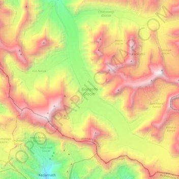
Name: Gangotri Glacier topographic map, elevation, terrain.
Location: Gangotri Glacier, Bhatwari, Uttarkashi, Uttarakhand, India (30.73027 79.07689 30.92663 79.27806)
Average elevation: 5,259 m
Minimum elevation: 3,530 m
Maximum elevation: 7,020 m
Make a donation
Gear up for your next adventure:
As an Amazon Associate, this site earns from qualifying purchases at no extra cost to you.
Other topographic maps
Click on a map to view its topography, its elevation and its terrain.
Uttarkashi
India > Uttarakhand > Bhatwari
It is the district headquarters of Uttarkashi district. Uttarkashi is situated on the banks of river Bhagirathi at an altitude of 1158 m above sea level. Uttarkashi is generally known as a holy town close to Rishikesh. It is located in the state of Uttarakhand in India. Uttarkashi is home to a number of…
Average elevation: 1,619 m
Make a donation
Gear up for your next adventure:
As an Amazon Associate, this site earns from qualifying purchases at no extra cost to you.
Make a donation
Gear up for your next adventure:
As an Amazon Associate, this site earns from qualifying purchases at no extra cost to you.
Gomukh, Ice Cave
India > Uttarakhand > Bhatwari
Around the snout, nature presents a wild topography. There are boulders scattered here and there with some pieces of broken snow, along with the hard clayey snow of the glacier.
Average elevation: 4,286 m
Make a donation
Gear up for your next adventure:
As an Amazon Associate, this site earns from qualifying purchases at no extra cost to you.
Sudarshan Parbat
India > Uttarakhand > Bhatwari
Sudarshan Parbat is a mountain of the Garhwal Himalaya in Uttarakhand India.The elevation of Sudarshan Parbat is 6,529 metres (21,421 ft) and its prominence is 456 metres (1,496 ft). It is joint 87th highest located entirely within the Uttrakhand. Nanda Devi, is the highest mountain in this category. Sudarshan…
Average elevation: 5,792 m
Make a donation
Gear up for your next adventure:
As an Amazon Associate, this site earns from qualifying purchases at no extra cost to you.
Make a donation
Gear up for your next adventure:
As an Amazon Associate, this site earns from qualifying purchases at no extra cost to you.