Geolocate

Buram topographic map

Click on the map to display elevation.

About this map

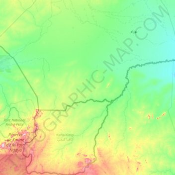
Name: Buram topographic map, elevation, terrain.

Location: Buram, South Darfur, Sudan (8.68528 23.44778 10.96727 25.38776)

Average elevation: 594 m

Minimum elevation: 455 m

Maximum elevation: 1,353 m

Other topographic maps

Click on a map to view its topography, its elevation and its terrain.

Nyala

Sudan > South Darfur > Nyala

Average elevation: 677 m

Faki Sadiq

Sudan > South Darfur > Kas > Shattai

Average elevation: 827 m

El Fifi

Sudan > South Darfur

Average elevation: 487 m

Gear up for your next adventure:

🛌Sleeping Bags - Warm and packable sleeping bags for outdoor nights
🧰First Aid Kits - Essential safety kits for outdoor activities
📕Outdoor Navigation Books - Learn traditional and modern navigation techniques
Lightweight Tents - Compact tents for backpacking and trekking
🥄Titanium Camping Sporks - The ultimate lightweight utensil for trail meals

As an Amazon Associate, this site earns from qualifying purchases at no extra cost to you.