Geolocate

Aggenstein topographic map

Click on the map to display elevation.

About this map

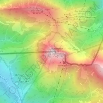
Name: Aggenstein topographic map, elevation, terrain.

Location: Aggenstein, Grän, Bezirk Reutte, Tyrol, 6673, Austria (47.53717 10.55760 47.53727 10.55770)

Average elevation: 1,478 m

Minimum elevation: 1,068 m

Maximum elevation: 1,932 m

Other topographic maps

Click on a map to view its topography, its elevation and its terrain.

Reutte

Austria > Tyrol > Bezirk Reutte

Average elevation: 1,372 m

Gramais

Austria > Tyrol > Bezirk Reutte

Average elevation: 1,918 m

Steeg

Austria > Tyrol > Bezirk Reutte

Average elevation: 1,876 m

Vils

Austria > Tyrol > Bezirk Reutte

Average elevation: 1,159 m

Namlos

Austria > Tyrol > Bezirk Reutte

Average elevation: 1,714 m

Reutte

Austria > Tyrol > Bezirk Reutte

Average elevation: 1,372 m

Reutte

Austria > Tyrol > Bezirk Reutte

Average elevation: 1,372 m

Ehrwald

Austria > Tyrol > Bezirk Reutte

Average elevation: 1,470 m

Bach

Austria > Tyrol > Bezirk Reutte

Average elevation: 1,784 m

Lermoos

Austria > Tyrol > Bezirk Reutte

Average elevation: 1,356 m

Jungholz

Austria > Tyrol > Bezirk Reutte > Jungholz

Average elevation: 1,139 m

Biberwier

Austria > Tyrol > Bezirk Reutte

Average elevation: 1,479 m

Gear up for your next adventure:

🗺️Ordnance Survey Maps - Essential paper maps for hiking across the UK national parks
📍Handheld GPS Navigators - Reliable satellite navigation for hiking and off-road exploration
🧰Survival Kits - Emergency tools for remote environments
🧵Survival Paracord - Multi-purpose cordage for emergency repairs and shelters
Insulated Travel Mugs - Keep drinks hot while surveying the landscape from a summit

As an Amazon Associate, this site earns from qualifying purchases at no extra cost to you.