Geolocate

Steeg topographic map

Click on the map to display elevation.

About this map

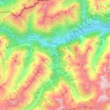
Name: Steeg topographic map, elevation, terrain.

Location: Steeg, Bezirk Reutte, Tyrol, 6655, Austria (47.17133 10.17421 47.28811 10.32576)

Average elevation: 1,876 m

Minimum elevation: 1,072 m

Maximum elevation: 2,874 m

Other topographic maps

Click on a map to view its topography, its elevation and its terrain.

Aggenstein

Austria > Tyrol > Bezirk Reutte

Average elevation: 1,478 m

Tannheim Mountains

Austria > Tyrol > Bezirk Reutte > Musau

Average elevation: 1,646 m

Lähn

Austria > Tyrol > Bezirk Reutte

Average elevation: 1,049 m

Hochvogel

Austria > Tyrol > Bezirk Reutte > Hinterhornbach

Average elevation: 1,897 m

Gear up for your next adventure:

🛌Sleeping Mats - Insulated mats for comfortable outdoor sleeping
🧢Hiking Hats - Sun and weather protection for outdoor walks
🧥Breathable Waterproof Jackets - Essential rain protection for the unpredictable British climate
📸Action Camera Chest Mounts - Record your ascent following topographic paths hands-free
📱Phone Mounts for Hiking - Secure mounts to carry your phone on trails

As an Amazon Associate, this site earns from qualifying purchases at no extra cost to you.