
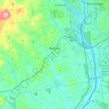
Bedford topographic map
Interactive map
Click on the map to display elevation.
About this map
Name: Bedford topographic map, elevation, terrain.
Average elevation: 97 m
Minimum elevation: 29 m
Maximum elevation: 402 m
Other topographic maps
Click on a map to view its topography, its elevation and its terrain.
Brookline
United States > New Hampshire > Hillsborough County
Brookline, Hillsborough County, New Hampshire, 03033, United States
Average elevation: 126 m
Milford
United States > New Hampshire > Hillsborough County
Milford, Hillsborough County, New Hampshire, 03055, United States
Average elevation: 114 m
Peterborough
United States > New Hampshire > Hillsborough County
Peterborough, Hillsborough County, New Hampshire, United States
Average elevation: 304 m
Bennington
United States > New Hampshire > Hillsborough County
Bennington, Hillsborough County, New Hampshire, 03442, United States
Average elevation: 260 m
Hillsboro Lower Village
United States > New Hampshire > Hillsborough County > Hillsborough
Hillsboro Lower Village, Hillsborough, Hillsborough County, New Hampshire, 03244, United States
Average elevation: 242 m
Campbell Mountain
United States > New Hampshire > Hillsborough County > Hillsborough
Campbell Mountain, Hillsborough, Hillsborough County, New Hampshire, United States
Average elevation: 338 m
Hollis
United States > New Hampshire > Hillsborough County
Hollis, Hillsborough County, New Hampshire, United States
Average elevation: 101 m
Temple
United States > New Hampshire > Hillsborough County
Temple, Hillsborough County, New Hampshire, 03084, United States
Average elevation: 346 m
Massachusetts Drive Park
United States > New Hampshire > Hillsborough County > Nashua
Massachusetts Drive Park, Ward 7, Nashua, Hillsborough County, New Hampshire, United States
Average elevation: 48 m
Greenfield
United States > New Hampshire > Hillsborough County > Greenfield
Greenfield, Hillsborough County, New Hampshire, 03047, United States
Average elevation: 288 m
Wilton
United States > New Hampshire > Hillsborough County
Wilton, Hillsborough County, New Hampshire, 03086, United States
Average elevation: 179 m
North Brookline
United States > New Hampshire > Hillsborough County > Brookline > North Brookline
North Brookline, Brookline, Hillsborough County, New Hampshire, 03033, United States
Average elevation: 124 m
Nashua
United States > New Hampshire > Hillsborough County
Nashua, Hillsborough County, New Hampshire, United States
Average elevation: 62 m
South Weare
United States > New Hampshire > Hillsborough County > Weare > South Weare
South Weare, Weare, Hillsborough County, New Hampshire, 03281, United States
Average elevation: 210 m
Nashua
United States > New Hampshire > Hillsborough County > Nashua
Nashua, Hillsborough County, New Hampshire, 03060-03064, United States
Average elevation: 82 m
Weare
United States > New Hampshire > Hillsborough County
Weare, Hillsborough County, New Hampshire, United States
Average elevation: 210 m
Hudson
United States > New Hampshire > Hillsborough County
Hudson, Hillsborough County, New Hampshire, 03051, United States
Average elevation: 68 m
Nakuru Lake
United States > New Hampshire > Hillsborough County > Hudson > Hudson Center
Nakuru Lake, Hudson Center, Hudson, Hillsborough County, New Hampshire, United States
Average elevation: 80 m
Manchester
United States > New Hampshire > Hillsborough County
Manchester, Hillsborough County, New Hampshire, United States
Average elevation: 96 m
New Boston
United States > New Hampshire > Hillsborough County
New Boston, Hillsborough County, New Hampshire, 03070, United States
Average elevation: 192 m
Hillsborough
United States > New Hampshire > Hillsborough County
Hillsborough, Hillsborough County, New Hampshire, 03244, United States
Average elevation: 298 m
Pelham
United States > New Hampshire > Hillsborough County
Pelham, Hillsborough County, New Hampshire, 03076, United States
Average elevation: 69 m
Amherst
United States > New Hampshire > Hillsborough County > Amherst
Amherst, Hillsborough County, New Hampshire, 03031, United States
Average elevation: 127 m
Merrimack
United States > New Hampshire > Hillsborough County > Merrimack
Merrimack, Hillsborough County, New Hampshire, 03054, United States
Average elevation: 68 m
Goffstown
United States > New Hampshire > Hillsborough County
Goffstown, Hillsborough County, New Hampshire, 03045, United States
Average elevation: 159 m