
Hollis topographic map
Interactive map
Click on the map to display elevation.
About this map
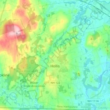
Name: Hollis topographic map, elevation, terrain.
Location: Hollis, Hillsborough County, New Hampshire, United States (42.70280 -71.64186 42.80359 -71.52490)
Average elevation: 101 m
Minimum elevation: 46 m
Maximum elevation: 246 m
Other topographic maps
Click on a map to view its topography, its elevation and its terrain.
West Peterborough
United States > New Hampshire > Hillsborough County > Peterborough
Average elevation: 299 m
Hillsboro Lower Village
United States > New Hampshire > Hillsborough County > Hillsborough
Average elevation: 242 m
Campbell Mountain
United States > New Hampshire > Hillsborough County > Hillsborough
Average elevation: 338 m
Temple
United States > New Hampshire > Hillsborough County
Terrain is generally uneven and rocky. It is also elevated, commanding distant views to the east and south. As John Farmer and Jacob Bailey Moore wrote in 1823, "From the highest point of elevation, twenty meetinghouses may be seen when the atmosphere is clear."
Average elevation: 346 m
Massachusetts Drive Park
United States > New Hampshire > Hillsborough County > Nashua
Average elevation: 48 m
Greenfield
United States > New Hampshire > Hillsborough County > Greenfield
According to the United States Census Bureau, the town has a total area of 26.8 square miles (69.3 km2), of which 26.2 square miles (67.9 km2) are land and 0.54 square miles (1.4 km2) are water, comprising 2.04% of the town. The southeast part of Greenfield is drained by Stony Brook, flowing southeast to the…
Average elevation: 288 m
North Brookline
United States > New Hampshire > Hillsborough County > Brookline > North Brookline
Average elevation: 124 m
South Weare
United States > New Hampshire > Hillsborough County > Weare > South Weare
Average elevation: 210 m
Nakuru Lake
United States > New Hampshire > Hillsborough County > Hudson > Hudson Center
Average elevation: 80 m
Manchester
United States > New Hampshire > Hillsborough County
According to the United States Census Bureau, the city has a total area of 35.0 square miles (90.6 km2), of which 33.1 square miles (85.7 km2) are land and 1.9 square miles (4.8 km2) are water, comprising 5.33% of the city. Manchester is drained by the Merrimack River and its tributaries the Piscataquog River…
Average elevation: 96 m
New Boston
United States > New Hampshire > Hillsborough County
According to the United States Census Bureau, the town has a total area of 43.2 square miles (111.9 km2), of which 42.8 square miles (110.9 km2) are land and 0.39 square miles (1.0 km2) are water, comprising 0.92% of the town. New Boston is drained by the South Branch and Middle Branch of the Piscataquog…
Average elevation: 193 m
North Village
United States > New Hampshire > Hillsborough County > Peterborough
Average elevation: 251 m
Amherst
United States > New Hampshire > Hillsborough County
According to the United States Census Bureau, the town has a total area of 34.7 square miles (89.9 km2), of which 34.2 square miles (88.5 km2) is land and 0.54 square miles (1.4 km2), or 1.51% of the total area, is water. Located on the Souhegan River, Amherst is drained by Beaver, Bloody, and Joe English…
Average elevation: 127 m