
Dupnitsa topographic map
Interactive map
Click on the map to display elevation.
Dupnitsa
Dupnitsa is located at an altitude of 500 m in a valley, surrounded by hills. Its location, as seen from above, resembles a hole (дупка, dupka in Bulgarian), hence the name Dupnitsa. There are five rivers flowing in the vicinity.
About this map
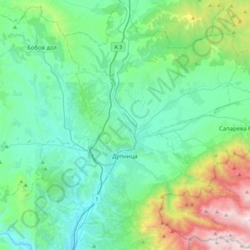
Name: Dupnitsa topographic map, elevation, terrain.
Location: Dupnitsa, Kyustendil, Bulgaria (42.17250 23.00407 42.41081 23.32018)
Average elevation: 854 m
Minimum elevation: 382 m
Maximum elevation: 2,651 m
Other topographic maps
Click on a map to view its topography, its elevation and its terrain.
Kyustendil
Kyustendil is a national balneological resort at an altitude of 600 metres. There are more than 40 mineral springs in the town. The waters have a high content of sulfite compounds. These are used for the treatment of the locomotory system, gynecological and other kinds of diseases. The resort region includes…
Average elevation: 937 m