
Longs Store topographic map
Click on the map to display elevation.
About this map
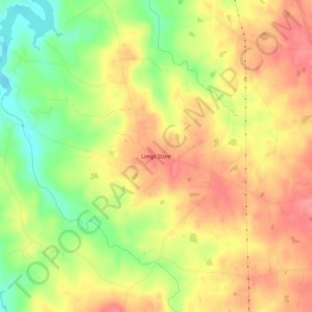
Name: Longs Store topographic map, elevation, terrain.
Location: Longs Store, Person County, North Carolina, United States (36.39403 -79.09807 36.43403 -79.05807)
Average elevation: 168 m
Minimum elevation: 122 m
Maximum elevation: 201 m
Other topographic maps
Click on a map to view its topography, its elevation and its terrain.
Roxboro
United States > North Carolina > Person County
Roxboro receives an average of 7.2 in (183 mm) of snow per winter. Freezing rain and sleet occur most winters, and occasionally the area experiences a major, damaging ice storm. Roxboro is often dubbed the "Snow Capital of the Triangle" because it often receives the most or close to the most snow during…
Average elevation: 191 m
Roxboro
United States > North Carolina > Person County
Roxboro receives an average of 7.2 in (180 mm) of snow per winter. Freezing rain and sleet occur most winters, and occasionally the area experiences a major, damaging ice storm. Roxboro is often dubbed the "Snow Capital of the Triangle" because it often receives the most or close to the most snow during…
Average elevation: 191 m