Geolocate

Hanmer topographic map

Click on the map to display elevation.

About this map

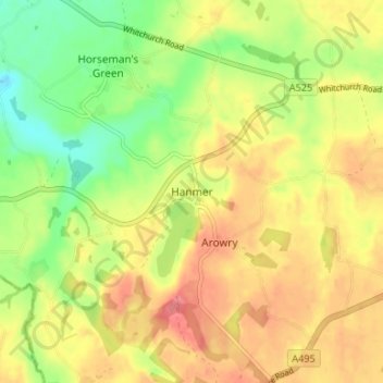
Name: Hanmer topographic map, elevation, terrain.

Location: Hanmer, Wrexham, Wales, SY13 3DE, United Kingdom (52.93228 -2.83284 52.97228 -2.79284)

Average elevation: 84 m

Minimum elevation: 46 m

Maximum elevation: 116 m

Other topographic maps

Click on a map to view its topography, its elevation and its terrain.

Penycae

United Kingdom > Wales > Wrexham

Average elevation: 350 m

Rhosddu

United Kingdom > Wales > Wrexham

Average elevation: 88 m

Gwersyllt

United Kingdom > Wales > Wrexham

Average elevation: 112 m

Bangor-on-Dee

United Kingdom > Wales > Wrexham

Average elevation: 30 m

Cefn

United Kingdom > Wales > Wrexham > Acrefair

Average elevation: 142 m

Gear up for your next adventure:

❄️Walking Crampons - Added traction for icy slopes and winter peak bagging
🧘Folding Sit Mats - Dry and warm seat for map-reading breaks on damp ground
🛌Insulated Sleeping Mats - Crucial thermal protection when sleeping on cold, uneven ground
📦Dry Bags - Waterproof bags to protect gear from rain
🌦️Portable Weather Meters - Handheld tools for monitoring weather conditions

As an Amazon Associate, this site earns from qualifying purchases at no extra cost to you.