
Make a donation
Gear up for your next adventure:
As an Amazon Associate, this site earns from qualifying purchases at no extra cost to you.
Abercorn topographic map
Click on the map to display elevation.
Make a donation
Gear up for your next adventure:
As an Amazon Associate, this site earns from qualifying purchases at no extra cost to you.
About this map
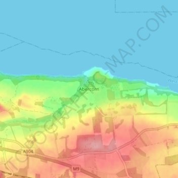
Name: Abercorn topographic map, elevation, terrain.
Location: Abercorn, West Lothian, Scotland, EH30 9SL, United Kingdom (55.97488 -3.49501 56.01488 -3.45501)
Average elevation: 36 m
Minimum elevation: 0 m
Maximum elevation: 109 m
West Lothian trails, hiking, mountain biking, running and outdoor activities
Make a donation
Gear up for your next adventure:
As an Amazon Associate, this site earns from qualifying purchases at no extra cost to you.
Other topographic maps
Click on a map to view its topography, its elevation and its terrain.
Linlithgow Palace and High Street Conservation Area
United Kingdom > Scotland > West Lothian > Linlithgow
Average elevation: 78 m
Make a donation
Gear up for your next adventure:
As an Amazon Associate, this site earns from qualifying purchases at no extra cost to you.