
Make a donation
Gear up for your next adventure:
As an Amazon Associate, this site earns from qualifying purchases at no extra cost to you.
Tenero-Contra topographic map
Click on the map to display elevation.
Make a donation
Gear up for your next adventure:
As an Amazon Associate, this site earns from qualifying purchases at no extra cost to you.
About this map
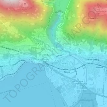
Name: Tenero-Contra topographic map, elevation, terrain.
Average elevation: 424 m
Minimum elevation: 190 m
Maximum elevation: 1,255 m
Make a donation
Gear up for your next adventure:
As an Amazon Associate, this site earns from qualifying purchases at no extra cost to you.
Other topographic maps
Click on a map to view its topography, its elevation and its terrain.
Make a donation
Gear up for your next adventure:
As an Amazon Associate, this site earns from qualifying purchases at no extra cost to you.
Sonogno
Switzerland > Ticino > Distretto di Locarno > Verzasca
The village is located in the Locarno district, Sonogno is the last village on the paved road through the Valley Verzasca. All motor vehicles are required to park at the entrance to the village. It is located at an elevation of 918 m (3,012 ft) about 30 km (19 mi) from Locarno.
Average elevation: 1,434 m
Passo dell'Alpe di Neggia
Switzerland > Ticino > Distretto di Locarno > Gambarogno > Rii
Average elevation: 1,319 m
Make a donation
Gear up for your next adventure:
As an Amazon Associate, this site earns from qualifying purchases at no extra cost to you.
Frasco
Switzerland > Ticino > Distretto di Locarno > Verzasca
The village is located in the Locarno district. It consists of the village of Frasco and multiple scattered settlements along the road in the upper Verzasca valley. The average elevation of the settlements is about 880 meters (2,890 ft).
Average elevation: 1,393 m
Ponte Brolla
Switzerland > Ticino > Distretto di Locarno > Terre di Pedemonte > Tegna
Average elevation: 537 m
Valle Verzasca
Switzerland > Ticino > Distretto di Locarno > Verzasca
Located between the Leventina and the Valle Maggia valleys, Valle Verzasca extends over a length of 25 kilometres (16 mi) in north–south direction and is situated in the north of the Lago Maggiore. The valley floor is at about 500 metres (1,640 ft) to 900 metres (2,953 ft) above sea level. The surrounding…
Average elevation: 1,398 m
Make a donation
Gear up for your next adventure:
As an Amazon Associate, this site earns from qualifying purchases at no extra cost to you.
Vergeletto
Switzerland > Ticino > Distretto di Locarno > Onsernone > Vergeletto
Average elevation: 1,332 m
Make a donation
Gear up for your next adventure:
As an Amazon Associate, this site earns from qualifying purchases at no extra cost to you.