
Poroto topographic map
Interactive map
Click on the map to display elevation.
About this map
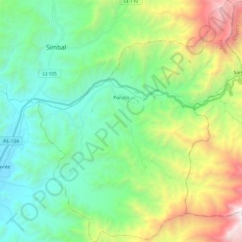
Name: Poroto topographic map, elevation, terrain.
Location: Poroto, Trujillo, La Libertad, Perú (-8.11176 -78.82641 -7.94378 -78.68304)
Average elevation: 1,141 m
Minimum elevation: 220 m
Maximum elevation: 3,476 m
Other topographic maps
Click on a map to view its topography, its elevation and its terrain.
Achupalla
Perú > La Libertad > Chugay
Achupalla, Chugay, Sánchez Carrión, La Libertad, Perú
Average elevation: 3,000 m
Pilancon
Perú > La Libertad > Retamas > Parcoy
Pilancon, Retamas, Parcoy, Pataz, La Libertad, Perú
Average elevation: 3,482 m
El Milagro
El Milagro, Huanchaco, Trujillo, La Libertad, Perú
Average elevation: 151 m