
Phúc Yên topographic map
Interactive map
Click on the map to display elevation.
About this map
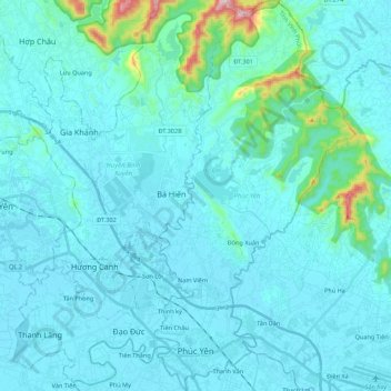
Name: Phúc Yên topographic map, elevation, terrain.
Location: Phúc Yên, Vinh Phuc Province, 84211, Vietnam (21.21248 105.68046 21.41623 105.79290)
Average elevation: 49 m
Minimum elevation: 4 m
Maximum elevation: 518 m
Other topographic maps
Click on a map to view its topography, its elevation and its terrain.
Thanh Lãng
Vietnam > Vinh Phuc Province > Bình Xuyên District
Thanh Lãng, Bình Xuyên District, Vĩnh Phúc Province, Vietnam
Average elevation: 10 m
Tam Đảo District
Tam Đảo District, Vinh Phuc Province, Vietnam
Average elevation: 213 m
Đồng Xuân
Vietnam > Vinh Phuc Province > Phúc Yên
Đồng Xuân, Phúc Yên, Vĩnh Phúc Province, Vietnam
Average elevation: 22 m