
Kabul Province topographic map
Interactive map
Click on the map to display elevation.
About this map
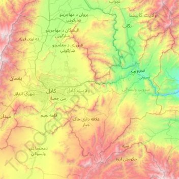
Name: Kabul Province topographic map, elevation, terrain.
Location: Kabul Province, Afghanistan (34.14516 68.83353 34.90711 69.94387)
Average elevation: 2,166 m
Minimum elevation: 804 m
Maximum elevation: 4,727 m
Other topographic maps
Click on a map to view its topography, its elevation and its terrain.
Bagrami
Afghanistan > Kabul Province > Bagrami District
Bagrami, Bagrami District, Kabul Province, Afghanistan
Average elevation: 1,801 m
Kabul District
Kabul District, Kabul Province, Afghanistan
Average elevation: 1,968 m
Kabul
Afghanistan > Kabul Province > Kabul District
Kabul, Kabul District, Kabul Province, 1001, Afghanistan
Average elevation: 1,945 m
Paghman
Afghanistan > Kabul Province > Paghman
Paghman, Kabul Province, Afghanistan
Average elevation: 2,606 m
Surobi
Afghanistan > Kabul Province > Surobi > Surobi
Surobi, Kabul Province, Afghanistan
Average elevation: 1,520 m
Chashmah-ye Masti
Afghanistan > Kabul Province > Surobi > Chashmah-ye Masti
Chashmah-ye Masti, Surobi, Kabul Province, Afghanistan
Average elevation: 1,425 m
Shakardara
Shakardara, Kabul Province, 1061, Afghanistan
Average elevation: 2,281 m