
Sámara topographic map
Interactive map
Click on the map to display elevation.
About this map
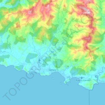
Name: Sámara topographic map, elevation, terrain.
Location: Sámara, Cantón Nicoya, Provincia Guanacaste, 50205, Costa Rica (9.85972 -85.63692 9.96349 -85.46270)
Average elevation: 160 m
Minimum elevation: -1 m
Maximum elevation: 781 m
Other topographic maps
Click on a map to view its topography, its elevation and its terrain.
Punta Indio
Costa Rica > Cantón Nicoya > Sámara
Punta Indio, Sámara, Cantón Nicoya, Provincia Guanacaste, 50205, Costa Rica
Average elevation: 5 m
Nosara
Nosara, Cantón Nicoya, Provincia Guanacaste, 50206, Costa Rica
Average elevation: 118 m