
Celestine topographic map
Interactive map
Click on the map to display elevation.
About this map
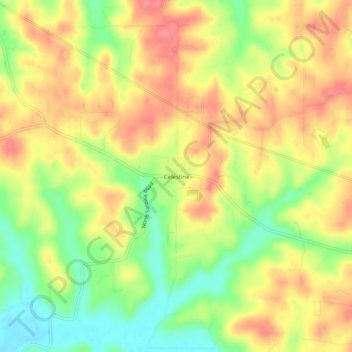
Name: Celestine topographic map, elevation, terrain.
Location: Celestine, Dubois County, Indiana, 47580, United States (38.36478 -86.79916 38.40478 -86.75916)
Average elevation: 185 m
Minimum elevation: 143 m
Maximum elevation: 219 m
Other topographic maps
Click on a map to view its topography, its elevation and its terrain.
Hillham
United States > Indiana > Dubois County
Hillham, Dubois County, Indiana, United States
Average elevation: 208 m
Jasper
United States > Indiana > Dubois County > Jasper
Jasper, Dubois County, Indiana, 47546, United States
Average elevation: 150 m
Holland
United States > Indiana > Dubois County > Holland
Holland, Dubois County, Indiana, United States
Average elevation: 155 m
Jasper
United States > Indiana > Dubois County > Jasper
Jasper, Dubois County, Indiana, United States
Average elevation: 151 m
Huntingburg
United States > Indiana > Dubois County
Huntingburg, Dubois County, Indiana, 47542, United States
Average elevation: 148 m
Ferdinand
United States > Indiana > Dubois County
Ferdinand, Dubois County, Indiana, 47532, United States
Average elevation: 162 m