
Puli Township topographic map
Interactive map
Click on the map to display elevation.
About this map
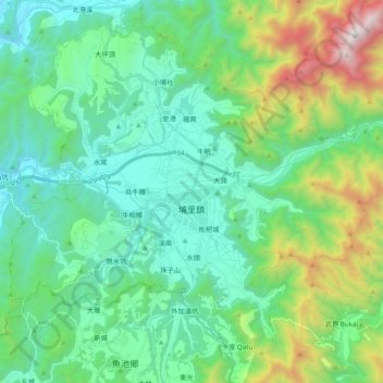
Name: Puli Township topographic map, elevation, terrain.
Location: Puli Township, Nantou County, Taiwan Province, Taiwan (23.89544 120.87856 24.05325 121.06953)
Average elevation: 784 m
Minimum elevation: 291 m
Maximum elevation: 2,398 m
Other topographic maps
Click on a map to view its topography, its elevation and its terrain.
Yushan
Taiwan > Taiwan Province > Nantou County > Xinyi Township
Yushan, Xinyi Township, Nantou County, Taiwan Province, Taiwan
Average elevation: 3,411 m
Nantou City
Taiwan > Taiwan Province > Nantou County
Nantou City, Nantou County, Taiwan Province, Taiwan
Average elevation: 192 m