
Make a donation
Gear up for your next adventure:
As an Amazon Associate, this site earns from qualifying purchases at no extra cost to you.
Noda topographic map
Click on the map to display elevation.
Make a donation
Gear up for your next adventure:
As an Amazon Associate, this site earns from qualifying purchases at no extra cost to you.
About this map
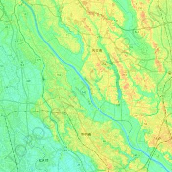
Name: Noda topographic map, elevation, terrain.
Location: Noda, Chiba Prefecture, Japan (35.91294 139.77595 36.10410 139.95189)
Average elevation: 13 m
Minimum elevation: 1 m
Maximum elevation: 28 m
Make a donation
Gear up for your next adventure:
As an Amazon Associate, this site earns from qualifying purchases at no extra cost to you.
Other topographic maps
Click on a map to view its topography, its elevation and its terrain.
Kanto
The surface geology of the Kanto Plain is the Quaternary alluvium and diluvium. The low mountain vegetation at an altitude of about 500 to 900 m in and around the plain is an evergreen broad-leaved forest zone. The distribution height range of laurel forests is 900m in Hakone, about 800m in Tanzawa and Takao,…
Average elevation: 265 m