
Petrovaradin topographic map
Interactive map
Click on the map to display elevation.
Petrovaradin
Petrovaradin is located in the Syrmia region, on the Danube river and Fruška Gora, a horst mountain with elevation of 78–220 m (municipality up to 451 m). The northern part of Fruška Gora consists of massive landslide zones, but they are not active, except in Ribnjak neighborhood (between Sremska Kamenica and Petrovaradin fortress).
About this map
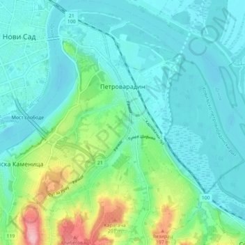
Name: Petrovaradin topographic map, elevation, terrain.
Average elevation: 105 m
Minimum elevation: 69 m
Maximum elevation: 238 m
Other topographic maps
Click on a map to view its topography, its elevation and its terrain.
Пуцкарош
Serbia > Vojvodina > South Backa Administrative District > Petrovaradin
Average elevation: 112 m
Banstol
Serbia > Vojvodina > South Backa Administrative District > Sremski Karlovci Municipality
Average elevation: 222 m
Bač
Serbia > Vojvodina > South Backa Administrative District > Bac Municipality
Average elevation: 83 m
Backi Jarak
Serbia > Vojvodina > South Backa Administrative District > Temerin Municipality
Average elevation: 81 m
Fruška gora
Serbia > Vojvodina > South Backa Administrative District > Beocin Municipality
Average elevation: 437 m
Backi Petrovac
Serbia > Vojvodina > South Backa Administrative District > Backi Petrovac Municipality
Average elevation: 82 m
Sremska Kamenica
Serbia > Vojvodina > South Backa Administrative District > Novi Sad City > Sremska Kamenica
Average elevation: 130 m
Becej
Serbia > Vojvodina > South Backa Administrative District > Becej Municipality
Average elevation: 78 m
Sremski Karlovci
Serbia > Vojvodina > South Backa Administrative District > Sremski Karlovci Municipality > Sremski Karlovci
Average elevation: 130 m