
Rancho Cordova topographic map
Interactive map
Click on the map to display elevation.
Rancho Cordova
In the Gold Rush era of mid-19th-century California, placer mining took place around Rancho Cordova, and some traces of it can still be found. The elevation of the generally level terrain is approximately 118 feet (36 m) above mean sea level. Lone Star Gravel Company and other companies have historically extracted younger gravels at depths of 30 to 40 feet (12 m) without encountering groundwater, which is characteristically found at about 100 feet (30 m). Partially confined groundwater generally flows to the southwest.
About this map
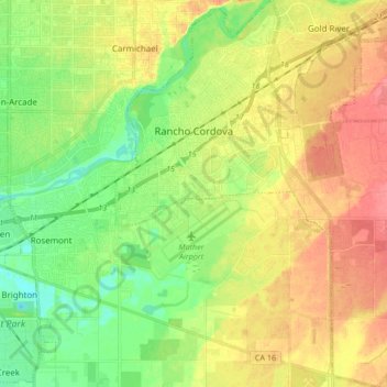
Name: Rancho Cordova topographic map, elevation, terrain.
Average elevation: 31 m
Minimum elevation: 4 m
Maximum elevation: 61 m
Other topographic maps
Click on a map to view its topography, its elevation and its terrain.
Rancho Murieta
United States > California > Sacramento County > Rancho Murieta
Average elevation: 91 m
Walnut Grove
United States > California > Sacramento County
Walnut Grove's location has made it the site of a rare collection of very tall radio and television transmission towers. The first major tower here was the KXTV/KOVR/KCRA Tower built in 1962, which dominated the skyline for over twenty years with its 1,548 foot height. In 1985 the old tower was joined by…
Average elevation: 1 m
Lexington Hills
United States > California > Sacramento County > Folsom > Lexington Hills
Average elevation: 121 m