
Saratoga Springs topographic map
Interactive map
Click on the map to display elevation.
About this map
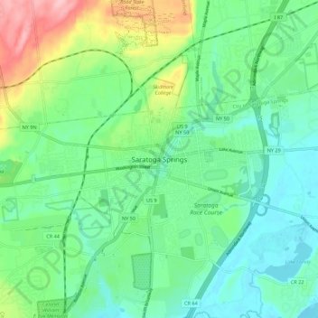
Name: Saratoga Springs topographic map, elevation, terrain.
Average elevation: 161 m
Minimum elevation: 18 m
Maximum elevation: 603 m
Other topographic maps
Click on a map to view its topography, its elevation and its terrain.
Gansevoort
United States > New York > Saratoga County
Gansevoort, Town of Northumberland, Saratoga County, New York, United States
Average elevation: 69 m
Saratoga National Historical Park
United States > New York > Saratoga County > Town of Stillwater
Saratoga National Historical Park, Town of Stillwater, Town of Saratoga, Saratoga County, New York, United States
Average elevation: 87 m
Town of Milton
United States > New York > Saratoga County
Town of Milton, Saratoga County, New York, United States
Average elevation: 117 m
Town of Wilton
United States > New York > Saratoga County
Town of Wilton, Saratoga County, New York, 12831, United States
Average elevation: 140 m
Village of Stillwater
United States > New York > Saratoga County
Village of Stillwater, Town of Stillwater, Saratoga County, New York, United States
Average elevation: 42 m
Town of Clifton Park
United States > New York > Saratoga County
Town of Clifton Park, Saratoga County, New York, United States
Average elevation: 85 m
Town of Malta
United States > New York > Saratoga County
Town of Malta, Saratoga County, New York, 12151, United States
Average elevation: 91 m
Ballston Lake
United States > New York > Saratoga County > Town of Clifton Park
Ballston Lake, Town of Clifton Park, Saratoga County, New York, 12019, United States
Average elevation: 107 m
City of Saratoga Springs
United States > New York > Saratoga County > City of Saratoga Springs
City of Saratoga Springs, Saratoga County, New York, 12866, United States
Average elevation: 97 m
Mechanicville
United States > New York > Saratoga County > City of Mechanicville > Mechanicville
Mechanicville, City of Mechanicville, Saratoga County, New York, 12118, United States
Average elevation: 62 m
Moreau
United States > New York > Saratoga County
Moreau, Saratoga County, New York, United States
Average elevation: 116 m