
Oldcotes topographic map
Click on the map to display elevation.
About this map
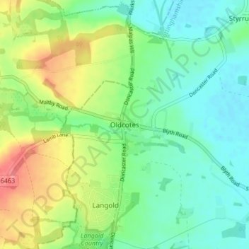
Name: Oldcotes topographic map, elevation, terrain.
Average elevation: 34 m
Minimum elevation: 9 m
Maximum elevation: 82 m
Nottinghamshire trails, hiking, mountain biking, running and outdoor activities
Other topographic maps
Click on a map to view its topography, its elevation and its terrain.
Beckingham
United Kingdom > England > Nottinghamshire > Bassetlaw > Beckingham
Average elevation: 17 m
Carlton in Lindrick
United Kingdom > England > Nottinghamshire > Bassetlaw > Carlton in Lindrick
Average elevation: 41 m
Creswell Crags
United Kingdom > England > Nottinghamshire > Bassetlaw > Holbeck
Average elevation: 79 m
Sturton le Steeple
United Kingdom > England > Nottinghamshire > Bassetlaw > Sturton le Steeple
Average elevation: 20 m
Beckingham
United Kingdom > England > Nottinghamshire > Bassetlaw > Beckingham
Average elevation: 17 m