
Make a donation
Gear up for your next adventure:
As an Amazon Associate, this site earns from qualifying purchases at no extra cost to you.
Misterton topographic map
Click on the map to display elevation.
Make a donation
Gear up for your next adventure:
As an Amazon Associate, this site earns from qualifying purchases at no extra cost to you.
About this map
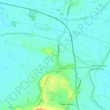
Name: Misterton topographic map, elevation, terrain.
Location: Misterton, Bassetlaw, Nottinghamshire, England, United Kingdom (53.43329 -0.92202 53.46629 -0.81940)
Average elevation: 6 m
Minimum elevation: -1 m
Maximum elevation: 33 m
Nottinghamshire trails, hiking, mountain biking, running and outdoor activities
Make a donation
Gear up for your next adventure:
As an Amazon Associate, this site earns from qualifying purchases at no extra cost to you.
Other topographic maps
Click on a map to view its topography, its elevation and its terrain.
Skegby
United Kingdom > England > Nottinghamshire > Bassetlaw > Normanton on Trent
Average elevation: 18 m
Mattersey Thorpe
United Kingdom > England > Nottinghamshire > Bassetlaw > Mattersey
Average elevation: 12 m
Retford
United Kingdom > England > Nottinghamshire > Bassetlaw
In 1831, the Gas Works was built by James Malam and gaslights were lit in the town for the first time on 22 December 1831. The Square was lit by a cast iron light bearing five gas lamps at that time. The Gas Works became a target on 2 September 1916 when a German Zeppelin dropped 14 bombs on Retford. The…
Average elevation: 31 m
Make a donation
Gear up for your next adventure:
As an Amazon Associate, this site earns from qualifying purchases at no extra cost to you.
Make a donation
Gear up for your next adventure:
As an Amazon Associate, this site earns from qualifying purchases at no extra cost to you.
Make a donation
Gear up for your next adventure:
As an Amazon Associate, this site earns from qualifying purchases at no extra cost to you.
Make a donation
Gear up for your next adventure:
As an Amazon Associate, this site earns from qualifying purchases at no extra cost to you.
Creswell Crags
United Kingdom > England > Nottinghamshire > Bassetlaw > Holbeck
Average elevation: 79 m
Make a donation
Gear up for your next adventure:
As an Amazon Associate, this site earns from qualifying purchases at no extra cost to you.
Littleborough
United Kingdom > England > Nottinghamshire > Bassetlaw > Littleborough
Average elevation: 10 m
Make a donation
Gear up for your next adventure:
As an Amazon Associate, this site earns from qualifying purchases at no extra cost to you.
Walkeringham
United Kingdom > England > Nottinghamshire > Bassetlaw > Walkeringham
Average elevation: 16 m
North Leverton with Habblesthorpe
United Kingdom > England > Nottinghamshire > Bassetlaw
Average elevation: 20 m
South Leverton
United Kingdom > England > Nottinghamshire > Bassetlaw > South Leverton
Average elevation: 22 m
Make a donation
Gear up for your next adventure:
As an Amazon Associate, this site earns from qualifying purchases at no extra cost to you.