Retford topographic map
Click on the map to display elevation.
Retford
In 1831, the Gas Works was built by James Malam and gaslights were lit in the town for the first time on 22 December 1831. The Square was lit by a cast iron light bearing five gas lamps at that time. The Gas Works became a target on 2 September 1916 when a German Zeppelin dropped 14 bombs on Retford. The Retford Times (8 September 1916) noted that bombs were dropped from Zeppelin L-13 into the orchard that surrounded the Gas Works, and although there wasn't a direct hit, shrapnel hit the sides of the gasometers setting them on fire. This fire was said to be so intense that according to the Retford Times "apples [were] baked on the trees, and roosting wild birds roasted alive". The Nottingham Daily Express (8 September 1916) reported that the Zeppelin then departed "at great altitude and terrific speed". The manager and his family were said to have had a very lucky escape as the shrapnel also hit their house. John Hook records that the Zeppelin left Retford at 1.05am, dropping a further bomb just south of Lea. One of the replacement gasometers later exploded on 16 March 1955, injuring 7 men and killing the manager. According to reports in The Retford Times, flames shot 200 feet into the air. The gasometers were finally dismantled when the town was connected to North Sea gas in the 1970s.
About this map
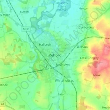
Name: Retford topographic map, elevation, terrain.
Average elevation: 31 m
Minimum elevation: 3 m
Maximum elevation: 100 m
Nottinghamshire trails, hiking, mountain biking, running and outdoor activities
Other topographic maps
Click on a map to view its topography, its elevation and its terrain.
Beckingham
United Kingdom > England > Nottinghamshire > Bassetlaw > Beckingham
Average elevation: 17 m

Creswell Crags
United Kingdom > England > Nottinghamshire > Bassetlaw > Holbeck
Average elevation: 79 m


West Burton
United Kingdom > England > Nottinghamshire > Bassetlaw
A topographical survey of the deserted village of West Burton was carried out by a team from Nottinghamshire County Council's community archaeology service in 2008–09.
Average elevation: 9 m
West Burton
United Kingdom > England > Nottinghamshire > Bassetlaw
A topographical survey of the deserted village of West Burton was carried out by a team from Nottinghamshire County Council's community archaeology service in 2008–09.
Average elevation: 9 m
Creswell Crags
United Kingdom > England > Nottinghamshire > Bassetlaw > Holbeck
Average elevation: 79 m
Sturton le Steeple
United Kingdom > England > Nottinghamshire > Bassetlaw > Sturton le Steeple
Average elevation: 20 m
Beckingham
United Kingdom > England > Nottinghamshire > Bassetlaw > Beckingham
Average elevation: 17 m