
Jacques-Cartier topographic map
Interactive map
Click on the map to display elevation.
About this map
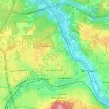
Name: Jacques-Cartier topographic map, elevation, terrain.
Location: Jacques-Cartier, Sherbrooke, Estrie, Québec, Canada (45.38410 -71.98523 45.44244 -71.88987)
Average elevation: 210 m
Minimum elevation: 138 m
Maximum elevation: 330 m
Other topographic maps
Click on a map to view its topography, its elevation and its terrain.
Fleurimont
Canada > Québec > Sherbrooke
Fleurimont, Sherbrooke, Estrie, Québec, Canada
Average elevation: 220 m
Sherbrooke
Canada > Québec > Sherbrooke
Sherbrooke, Estrie, Québec, J1H 1P1, Canada
Average elevation: 249 m