
Fleurimont topographic map
Interactive map
Click on the map to display elevation.
About this map
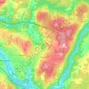
Name: Fleurimont topographic map, elevation, terrain.
Location: Fleurimont, Sherbrooke, Estrie, Québec, Canada (45.38232 -71.91675 45.45340 -71.80254)
Average elevation: 220 m
Minimum elevation: 135 m
Maximum elevation: 319 m
Other topographic maps
Click on a map to view its topography, its elevation and its terrain.
Sherbrooke
Canada > Québec > Sherbrooke
Sherbrooke, Estrie, Québec, J1H 1P1, Canada
Average elevation: 249 m
Jacques-Cartier
Canada > Québec > Sherbrooke
Jacques-Cartier, Sherbrooke, Estrie, Québec, Canada
Average elevation: 210 m