
Inner Mongolia topographic map
Interactive map
Click on the map to display elevation.
About this map
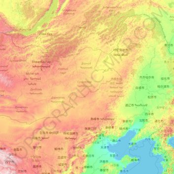
Name: Inner Mongolia topographic map, elevation, terrain.
Location: Inner Mongolia, China (37.40671 97.22502 53.33406 125.32729)
Average elevation: 891 m
Minimum elevation: -2 m
Maximum elevation: 4,757 m
Inner Mongolia largely consists of the northern side of the North China Craton, a tilted and sedimented Precambrian block. In the extreme southwest is the edge of the Tibetan Plateau where the autonomous region's highest peak, Main Peak in the Helan Mountains reaches 3,556 metres (11,670 ft), and is still being pushed up today in short bursts. Most of Inner Mongolia is a plateau averaging around 1,200 metres (3,940 ft) in altitude and covered by extensive loess and sand deposits. The northern part consists of the Mesozoic era Khingan Mountains, and is owing to the cooler climate more forested, chiefly with Manchurian elm, ash, birch, Mongolian oak and a number of pine and spruce species. Where discontinuous permafrost is present north of Hailar District, forests are almost exclusively coniferous. In the south, the natural vegetation is grassland in the east and very sparse in the arid west, and grazing is the dominant economic activity.
Other topographic maps
Click on a map to view its topography, its elevation and its terrain.
Gyama
China > Tibet > Mainling City > Tashi Rabten
Gyama, Tashi Rabten, Mainling City, Nyingchi Prefecture, Tibet, China
Average elevation: 3,093 m
Tingri County
Tingri County, Shigatse Prefecture, Tibet, 858200, China
Average elevation: 4,963 m
Kuiju
China > Shandong > Changyi City
Kuiju, Changyi City, Weifang, Shandong, 261300, China
Average elevation: 10 m
Dansa
China > Guangdong Province > Zhaoqing City
Dansa, Zhaoqing City, Guangdong Province, China
Average elevation: 81 m
Nyalam
China > Tibet > Nyalam County > Nyalam
Nyalam, Nyalam County, Shigatse Prefecture, Tibet, China
Average elevation: 4,756 m
兵团六十九团
China > Xinjiang > Chapchal Xibe Autonomous County
兵团六十九团, Chapchal Xibe Autonomous County, Ili, Xinjiang, China
Average elevation: 1,167 m
Xiwacun
China > Beijing > Haidian District
Xiwacun, Haidian District, Beijing, 100084, China
Average elevation: 48 m
Sanquzhuangcun
China > Hebei > Baoding City
Sanquzhuangcun, Baoding City, Hebei, China
Average elevation: 133 m
Longhua District
Longhua District, Shenzhen, Guangdong Province, 518110, China
Average elevation: 81 m
Heishui County
Heishui County, Ngawa Tibetan and Qiang Autonomous Prefecture, Sichuan, 623500, China
Average elevation: 3,656 m
Sanguniang Feng
China > Sichuan > Xiaojin County
Sanguniang Feng, Xiaojin County, Ngawa Tibetan and Qiang Autonomous Prefecture, Sichuan, 624200, China
Average elevation: 4,768 m
Baisha Li Autonomous County
Baisha Li Autonomous County, Hainan Province, China
Average elevation: 368 m
Yinggen
China > Hainan Province > Qiongzhong Li and Miao Autonomous County
Yinggen, Qiongzhong Li and Miao Autonomous County, Hainan Province, China
Average elevation: 308 m
Tianping Mountains
China > Guangxi > Luzhai County
Tianping Mountains, Luzhai County, Liuzhou City, Guangxi, China
Average elevation: 400 m
Ping
China > Guangxi > Sanjiang Dong Autonomous County > Chengyang
Ping, Chengyang, Sanjiang Dong Autonomous County, Liuzhou City, Guangxi, 545505, China
Average elevation: 287 m
Xiaojin
China > Sichuan > Xiaojin County
Xiaojin, Xiaojin County, Ngawa Tibetan and Qiang Autonomous Prefecture, Sichuan, 624200, China
Average elevation: 3,619 m
Pengyuan
China > Gansu > Zhenyuan County
Pengyuan, Zhenyuan County, Qingyang, Gansu, China
Average elevation: 1,158 m
曹州牡丹园
China > Shandong > Mudan District
曹州牡丹园, Mudan, Mudan District, Heze, Shandong, China
Average elevation: 52 m
Zhongchuan
China > Gansu > Lanzhou New Area
Zhongchuan, Lanzhou New Area, Lanzhou, Gansu, China
Average elevation: 1,917 m
Dabanqiao Subdistrict
Dabanqiao Subdistrict, Guandu District, Kunming, Yunnan, 650211, China
Average elevation: 2,093 m
Penglai District
Penglai District, Yantai, Shandong, 264000, China
Average elevation: 20 m
Qoghushluq
China > Xinjiang > Taxkorgan Tajik Autonomous County > 库科西鲁格乡 قوغۇشلۇق يېزىسى
Qoghushluq, 库科西鲁格乡 قوغۇشلۇق يېزىسى, Taxkorgan Tajik Autonomous County, Kachgar, Xinjiang, China
Average elevation: 2,984 m
Tahota Creek
China > Xinjiang > Pishan County
Tahota Creek, Pishan County, Hotan Prefecture, Xinjiang, China
Average elevation: 2,191 m
Mount Gongga
China > Sichuan > Luding County
Mount Gongga, Luding County, Kardze, Sichuan, 626100, China
Average elevation: 6,496 m
Qiongshan District
China > Hainan Province > Haikou City
Qiongshan District, Haikou City, Hainan Province, 571138, China
Average elevation: 47 m
Heye
China > Sichuan > Jiuzhaigou County
Heye, Jiuzhaigou County, Ngawa Tibetan and Qiang Autonomous Prefecture, Sichuan, 623400, China
Average elevation: 2,598 m
Hefeng
China > Hubei > Hefeng County
Hefeng, Hefeng County, Enshi, Hubei, 445800, China
Average elevation: 1,115 m
Yuexiu District
Yuexiu District, Guangzhou City, Guangdong Province, China
Average elevation: 23 m