
Make a donation
Gear up for your next adventure:
As an Amazon Associate, this site earns from qualifying purchases at no extra cost to you.
Inner Mongolia topographic map
Click on the map to display elevation.
Make a donation
Gear up for your next adventure:
As an Amazon Associate, this site earns from qualifying purchases at no extra cost to you.
Inner Mongolia
Inner Mongolia largely consists of the northern side of the North China Craton, a tilted and sedimented Precambrian block. In the extreme southwest is the edge of the Tibetan Plateau where the autonomous region's highest peak, Main Peak in the Helan Mountains reaches 3,556 metres (11,670 ft), and is still being pushed up today in short bursts. Most of Inner Mongolia is a plateau averaging around 1,200 metres (3,940 ft) in altitude and covered by extensive loess and sand deposits. The northern part consists of the Mesozoic era Khingan Mountains, and is owing to the cooler climate more forested, chiefly with Manchurian elm, ash, birch, Mongolian oak and a number of pine and spruce species. Where discontinuous permafrost is present north of Hailar District, forests are almost exclusively coniferous. In the south, the natural vegetation is grassland in the east and very sparse in the arid west, and grazing is the dominant economic activity.
Make a donation
Gear up for your next adventure:
As an Amazon Associate, this site earns from qualifying purchases at no extra cost to you.
About this map
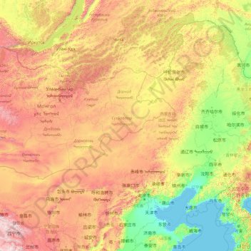
Name: Inner Mongolia topographic map, elevation, terrain.
Location: Inner Mongolia, China (37.40664 97.26948 53.33406 125.32729)
Average elevation: 890 m
Minimum elevation: -2 m
Maximum elevation: 4,789 m
Make a donation
Gear up for your next adventure:
As an Amazon Associate, this site earns from qualifying purchases at no extra cost to you.
Other topographic maps
Click on a map to view its topography, its elevation and its terrain.
Chongqing
The central urban area of Chongqing, or Chongqing proper, is a city of unique features. Built on mountains and partially surrounded by the Yangtze and Jialing rivers, it is known as a "mountain city" and a "city on rivers". The night scene of the city is very illuminated, with millions of lights and their…
Average elevation: 318 m
Shanghai
The golden age of Shanghai began with its elevation to municipality on 7 July 1927. This new Chinese municipality covered an area of 494.69 km2 (191.0 sq mi), including the modern-day districts of Baoshan, Yangpu, Zhabei, Nanshi, and Pudong, but excluded the foreign concessions territories. Headed by a Chinese…
Average elevation: 5 m
Mount Kailash
China > Tibet > Purang County > Darchen
Mount Kailash (also Kailasa; Kangrinboqê or Gang Rinpoche; Tibetan: གངས་རིན་པོ་ཆེ; simplified Chinese: 冈仁波齐峰; traditional Chinese: 岡仁波齊峰; Sanskrit: कैलास, IAST: Kailāsa), is a mountain in the Ngari Prefecture, Tibet Autonomous Region of China. It has an…
Average elevation: 5,756 m
Make a donation
Gear up for your next adventure:
As an Amazon Associate, this site earns from qualifying purchases at no extra cost to you.
Sunset Peak
Sunset Peak is only accessible by foot. It is located on section 2 of the 70 km (43 mi) long Lantau Trail. Section 2 is 6.5 km long and goes from Nam Shan Campsite west of Mui Wo on South Lantau Road (elevation about 120 m), to Pak Kung Au, another campsite on the Tung Chung Road (elevation about 340 m). Both…
Average elevation: 411 m
Gasherbrum II
China > Xinjiang > Taxkorgan Tajik Autonomous County > Dafdar
Gasherbrum II is located on the border of Gilgit–Baltistan, Pakistan, and Xinjiang, China. It is part of the Karakoram mountain range in the Himalayas, and located at the top of the Baltoro Glacier. With an elevation of 8,034 metres (26,358 ft) it is the third-highest member of the Gasherbrum group, behind…
Average elevation: 7,098 m
Make a donation
Gear up for your next adventure:
As an Amazon Associate, this site earns from qualifying purchases at no extra cost to you.
Make a donation
Gear up for your next adventure:
As an Amazon Associate, this site earns from qualifying purchases at no extra cost to you.
Tai Mo Shan
Tai Mo Shan is the highest peak in Hong Kong, with an elevation of 957 metres (3,140 ft) above the Hong Kong Principal Datum [zh], or around 956 metres (3,136 ft) above mean sea level. It is located at approximately the geographical centre of the New Territories.
Average elevation: 600 m
Beijing
Beijing is situated at the northern tip of the roughly triangular North China Plain, which opens to the south and east of the city. Mountains to the north, northwest and west shield the city and northern China's agricultural heartland from the encroaching desert steppes. The northwestern part of the…
Average elevation: 47 m
Broad Peak
China > Xinjiang > Taxkorgan Tajik Autonomous County > Dafdar
Broad Peak is one of the eight-thousanders, and is located in the Karakoram range spanning Gilgit-Baltistan, Pakistan and Xinjiang, China. It is the 12th highest mountain in the world at 8,051 metres (26,414 ft) elevation above sea level. The first ascent of this mountain was in June 1957, accomplished by…
Average elevation: 7,117 m
Himalayas
The Himalayas, or Himalaya, is a mountain range in Asia separating the plains of the Indian subcontinent from the Tibetan Plateau. The range has some of the Earth's highest peaks, including the highest, Mount Everest. More than 100 peaks exceeding elevations of 7,200 m (23,600 ft) above sea level lie in the…
Average elevation: 2,385 m
Make a donation
Gear up for your next adventure:
As an Amazon Associate, this site earns from qualifying purchases at no extra cost to you.
Xi'an
China > Shaanxi > Weiyang District > Xi'an
Xi'an lies on the Guanzhong Plain in the south-central part of Shaanxi province, on a flood plain created by the eight surrounding rivers and streams. The city has an average elevation of 400 metres (1,312 ft) above sea level and an annual precipitation of 553 mm (21.8 in). The urban area of Xi'an is located…
Average elevation: 412 m
Make a donation
Gear up for your next adventure:
As an Amazon Associate, this site earns from qualifying purchases at no extra cost to you.
Make a donation
Gear up for your next adventure:
As an Amazon Associate, this site earns from qualifying purchases at no extra cost to you.
Alar National Wetland Park
China > Xinjiang > Taxkorgan Tajik Autonomous County > Tashkorgan Town > 瓦尔希迭村 ۋەرشىدې
Average elevation: 3,074 m
Make a donation
Gear up for your next adventure:
As an Amazon Associate, this site earns from qualifying purchases at no extra cost to you.
Tagong
A gompa is where the Tagong Monastery is located. The gompa is one of the most important in the in Tibetan Pel Lhagong. The Tagong Monastery was established with reference to a nearby sacred mountain, Mt. Yala or Zhara Lhaste, which is 5,820 metres (19,090 ft) in elevation.
Average elevation: 3,874 m
Make a donation
Gear up for your next adventure:
As an Amazon Associate, this site earns from qualifying purchases at no extra cost to you.
Make a donation
Gear up for your next adventure:
As an Amazon Associate, this site earns from qualifying purchases at no extra cost to you.
Make a donation
Gear up for your next adventure:
As an Amazon Associate, this site earns from qualifying purchases at no extra cost to you.
Make a donation
Gear up for your next adventure:
As an Amazon Associate, this site earns from qualifying purchases at no extra cost to you.
Make a donation
Gear up for your next adventure:
As an Amazon Associate, this site earns from qualifying purchases at no extra cost to you.
Make a donation
Gear up for your next adventure:
As an Amazon Associate, this site earns from qualifying purchases at no extra cost to you.
Make a donation
Gear up for your next adventure:
As an Amazon Associate, this site earns from qualifying purchases at no extra cost to you.
Make a donation
Gear up for your next adventure:
As an Amazon Associate, this site earns from qualifying purchases at no extra cost to you.
Make a donation
Gear up for your next adventure:
As an Amazon Associate, this site earns from qualifying purchases at no extra cost to you.
Make a donation
Gear up for your next adventure:
As an Amazon Associate, this site earns from qualifying purchases at no extra cost to you.
Make a donation
Gear up for your next adventure:
As an Amazon Associate, this site earns from qualifying purchases at no extra cost to you.
Make a donation
Gear up for your next adventure:
As an Amazon Associate, this site earns from qualifying purchases at no extra cost to you.
Make a donation
Gear up for your next adventure:
As an Amazon Associate, this site earns from qualifying purchases at no extra cost to you.
Make a donation
Gear up for your next adventure:
As an Amazon Associate, this site earns from qualifying purchases at no extra cost to you.
Nyalam
China > Tibet > Nyalam County > Nyalam
The other town of the county is Zhangmu, also known by its Tibetan name Dram, or Nepali Khasa. It is located near the border and is the point of entry from Nepal. At "merely" 2,300 meters elevation about the sea level, Zhangmu has mild and humid subtropical climate, which is a rarity for Tibet.
Average elevation: 4,756 m
Shigatse
Shigatse Peace Airport began operations on 30 October 2010 after an Airbus A319 landed safely, making it Tibet's fifth commercial airport. It is located 43 kilometres from Samzhubzê District at Jangdam Township at an elevation of 3,782 metres. The airport will be capable of supporting 230,000 passengers…
Average elevation: 4,049 m
Make a donation
Gear up for your next adventure:
As an Amazon Associate, this site earns from qualifying purchases at no extra cost to you.
Yuanyang
China > Yunnan > Yuanyang County
It covers an area of 2,200 km2 (850 sq mi) and has a population of approximately 365,000 (2002), of which 88% belong to ethnic minorities and 95% is associated with agriculture. The majority of the inhabitants of the county are from the Hani ethnic group. The GDP of Yuanyang county in 2021 was 9,312 million…
Average elevation: 1,171 m
Make a donation
Gear up for your next adventure:
As an Amazon Associate, this site earns from qualifying purchases at no extra cost to you.
Make a donation
Gear up for your next adventure:
As an Amazon Associate, this site earns from qualifying purchases at no extra cost to you.
Make a donation
Gear up for your next adventure:
As an Amazon Associate, this site earns from qualifying purchases at no extra cost to you.