Geolocate

Beijing topographic map

Click on the map to display elevation.

Beijing

Beijing is situated at the northern tip of the roughly triangular North China Plain, which opens to the south and east of the city. Mountains to the north, northwest and west shield the city and northern China's agricultural heartland from the encroaching desert steppes. The northwestern part of the municipality, especially Yanqing District and Huairou District, are dominated by the Jundu Mountains, while the western part is framed by Xishan or the Western Hills. The Great Wall of China across the northern part of Beijing Municipality was built on the rugged topography to defend against nomadic incursions from the steppes. Mount Dongling, in the Western Hills and on the border with Hebei, is the municipality's highest point, with an altitude of 2,303 metres (7,556 ft).

Wikipedia (CC-BY-SA 3.0)

About this map

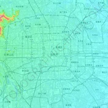
Name: Beijing topographic map, elevation, terrain.

Location: Beijing, Dongcheng District, Beijing, 100010, China (39.74571 116.23130 40.06571 116.55130)

Average elevation: 47 m

Minimum elevation: 18 m

Maximum elevation: 509 m

Other topographic maps

Click on a map to view its topography, its elevation and its terrain.

Dongcheng District

China > Beijing

Like most of Beijing, the district is consistently level, with an elevation of 30–50 metres (98–164 ft) above sea level, reflecting the city's location on the North China Plain. There are a few significant bodies of water, all lakes in parks—Liuyin Lake in that park and Youth Lake in Qingnianhu Park,…

Average elevation: 47 m

Haidian District

China > Beijing

Average elevation: 70 m

Haidian District

China > Beijing

Average elevation: 70 m

Chaoyang District

China > Beijing

Average elevation: 41 m

Miyun District

China > Beijing

Average elevation: 374 m

Mutianyu Great Wall

China > Beijing > Huairou District > Mutianyu

Average elevation: 430 m

Shangzhuang

China > Beijing > Haidian District

Average elevation: 46 m

Chaoyang District

China > Beijing

Average elevation: 41 m

Cuigezhuang

China > Beijing > Chaoyang District

Average elevation: 36 m

Chaoyang District

China > Beijing

Average elevation: 41 m

Fengtai District

China > Beijing

Average elevation: 62 m

Taishitun

China > Beijing > Miyun District

Average elevation: 334 m

Jinhai Lake

China > Beijing > Pinggu District > Hongshikancun

Average elevation: 127 m

Olympic Park

China > Beijing > Chaoyang District

Average elevation: 47 m

Shijingshan District

China > Beijing

Average elevation: 97 m

Xicheng District

China > Beijing

Average elevation: 97 m

Haidian District

China > Beijing

Average elevation: 70 m

Pinggu District

China > Beijing > Pinggu District

Average elevation: 223 m

Yanqing District

China > Beijing

The Yanqing Badaling Great Wall Basin is surrounded by mountains on three sides in the north, south, east, and Guanting Reservoir to the west, namely the Yanhuai Basin. Yanqing is located in the east of the basin, with an average elevation of about 500 meters. Haituo Mountain is the highest peak in the…

Average elevation: 806 m

Huairou District

China > Beijing

Average elevation: 568 m

Daxing District

China > Beijing > Daxing District

Average elevation: 35 m

Fangshan District

China > Beijing

Average elevation: 158 m

Fengtai District

China > Beijing

Average elevation: 62 m

Gear up for your next adventure:

🐕Hiking Dog Harnesses - Rugged harnesses for taking your companion on mountain trails
🥾Hiking Boots - Waterproof and durable boots for long-distance hiking in the UK
📐Altimeters & Barometers - Tools for measuring altitude and air pressure
👟Heavy Duty Boot Laces - Always carry a spare for your hiking footwear
🕶️Polarized Sunglasses - Reduces glare from snow and water when reading terrain

As an Amazon Associate, this site earns from qualifying purchases at no extra cost to you.