Geolocate

Sızma topographic map

Interactive map

Click on the map to display elevation.

About this map

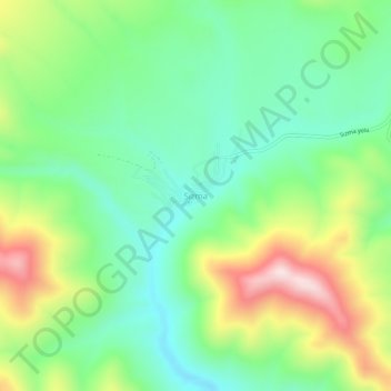
Name: Sızma topographic map, elevation, terrain.

Location: Sızma, Selçuklu, Konya, Central Anatolia Region, Turkey (38.06859 32.38371 38.10859 32.42371)

Average elevation: 1,528 m

Minimum elevation: 1,373 m

Maximum elevation: 1,817 m

Other topographic maps

Click on a map to view its topography, its elevation and its terrain.

Sille

Turkey > Selçuklu

Sille, Selçuklu, Konya, Central Anatolia Region, Turkey

Average elevation: 1,264 m

Konya

Turkey > Selçuklu

Konya, Selçuklu, Konya, Central Anatolia Region, 42200, Turkey

Average elevation: 1,160 m