Geolocate

Roxas topographic map

Click on the map to display elevation.

About this map

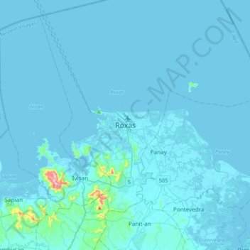
Name: Roxas topographic map, elevation, terrain.

Location: Roxas, Capiz, Western Visayas, Philippines (11.42952 122.59006 11.74952 122.91006)

Average elevation: 10 m

Minimum elevation: -3 m

Maximum elevation: 366 m

Other topographic maps

Click on a map to view its topography, its elevation and its terrain.

Sigma

Philippines > Capiz

Average elevation: 37 m

Sapi-an

Philippines > Capiz > Sapi-an

Average elevation: 31 m

Navitas

Philippines > Capiz > Panay > Navitas

Average elevation: 2 m

Gear up for your next adventure:

🎒Hiking Daypacks (20L) - Compact backpacks for day trips and technical mountain ascents
🌄Compact Monoculars - Lightweight optics for hiking
🔋Rechargeable Batteries - Eco-friendly power for headlamps and older GPS units
🔦Waterproof LED Headlamps - Hands-free lighting for evening treks and emergency navigation
🛑Emergency Bivvy Bags - Heat-reflective survival bags for unexpected nights out

As an Amazon Associate, this site earns from qualifying purchases at no extra cost to you.