Geolocate

Sigma topographic map

Click on the map to display elevation.

About this map

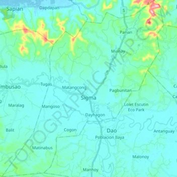
Name: Sigma topographic map, elevation, terrain.

Location: Sigma, Capiz, Western Visayas, Philippines (11.35598 122.59306 11.50115 122.72881)

Average elevation: 37 m

Minimum elevation: -2 m

Maximum elevation: 308 m

Other topographic maps

Click on a map to view its topography, its elevation and its terrain.

Artuz

Philippines > Capiz > Tapaz

Average elevation: 147 m

Nagba

Philippines > Capiz > Cuartero > Malagab-I

Average elevation: 27 m

Roxas

Philippines > Capiz

Average elevation: 10 m

Santo Angel

Philippines > Capiz > Santo Angel

Average elevation: 28 m

Navitas

Philippines > Capiz > Panay > Navitas

Average elevation: 2 m

Gear up for your next adventure:

🧤Thermal Touchscreen Gloves - Stay warm while operating your GPS or smartphone camera
Lightweight Solo Tents - Backpacking tents designed for wild camping in the UK highlands
🧰Survival Kits - Emergency tools for remote environments
🗺️Topographic Maps - Detailed maps showing elevation and terrain features
🥾Hiking Boots - Waterproof and durable boots for long-distance hiking in the UK

As an Amazon Associate, this site earns from qualifying purchases at no extra cost to you.