
Municipio de Retalhuleu topographic map
Interactive map
Click on the map to display elevation.
About this map
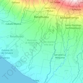
Name: Municipio de Retalhuleu topographic map, elevation, terrain.
Location: Municipio de Retalhuleu, Retalhuleu, Guatemala (14.19025 -92.16299 14.58941 -91.65483)
Average elevation: 139 m
Minimum elevation: 0 m
Maximum elevation: 1,066 m
Other topographic maps
Click on a map to view its topography, its elevation and its terrain.