Geolocate

Athens topographic map

Click on the map to display elevation.

About this map
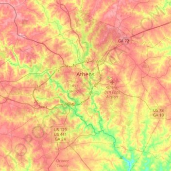
Name: Athens topographic map, elevation, terrain.

Location: Athens, Clarke County, Georgia, United States (33.84802 -83.53747 34.03947 -83.24083)

Average elevation: 219 m

Minimum elevation: 142 m

Maximum elevation: 276 m

Other topographic maps

Click on a map to view its topography, its elevation and its terrain.

Cherokee Forest

United States > Georgia > Clarke County > Athens

Average elevation: 217 m

Dam Number 10

United States > Georgia > Clarke County > Athens

Average elevation: 215 m

Dupont Dam

United States > Georgia > Clarke County > Athens

Average elevation: 237 m

Camelot

United States > Georgia > Clarke County > Athens

Average elevation: 218 m

Shoal Creek

United States > Georgia > Clarke County > Athens

Average elevation: 225 m

Gear up for your next adventure:

🔦LED Camping Lanterns - Illumination for reading maps inside your tent at night
📷Outdoor Action Cameras - Cameras designed for hiking and adventure
🧼Technical Clothing Wash - Special soap to clean and restore waterproof membranes
🧵Survival Paracord - Multi-purpose cordage for emergency repairs and shelters
🧷Tenacious Repair Tape - Instant fix for torn tents, jackets, or dry bags

As an Amazon Associate, this site earns from qualifying purchases at no extra cost to you.