Geolocate

Klütz topographic map

Interactive map

Click on the map to display elevation.

About this map

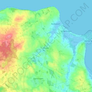
Name: Klütz topographic map, elevation, terrain.

Location: Klütz, Klützer Winkel, Nordwestmecklenburg, Mecklenburg-Vorpommern, 23948, Germany (53.92693 11.08674 54.01113 11.26726)

Average elevation: 22 m

Minimum elevation: -4 m

Maximum elevation: 85 m

Other topographic maps

Click on a map to view its topography, its elevation and its terrain.

Wismar

Germany > Mecklenburg-Vorpommern > Nordwestmecklenburg > Wismar > Wismar

Wismar, Nordwestmecklenburg, Mecklenburg-Vorpommern, 23966, Germany

Average elevation: 14 m

Grevesmühlen

Germany > Mecklenburg-Vorpommern > Nordwestmecklenburg

Grevesmühlen, Nordwestmecklenburg, Mecklenburg-Vorpommern, 23936, Germany

Average elevation: 39 m

Wismar

Germany > Mecklenburg-Vorpommern > Nordwestmecklenburg

Wismar, Nordwestmecklenburg, Mecklenburg-Vorpommern, Germany

Average elevation: 11 m

Testorf-Steinfort

Germany > Mecklenburg-Vorpommern > Nordwestmecklenburg

Testorf-Steinfort, Grevesmühlen-Land, Nordwestmecklenburg, Mecklenburg-Vorpommern, Germany

Average elevation: 53 m