
Testorf-Steinfort topographic map
Interactive map
Click on the map to display elevation.
About this map
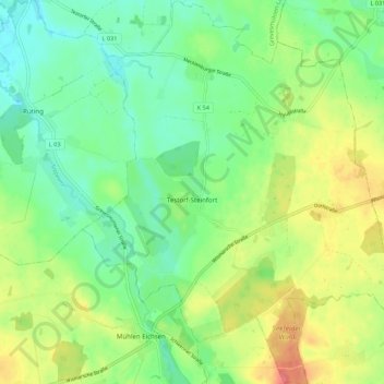
Name: Testorf-Steinfort topographic map, elevation, terrain.
Average elevation: 53 m
Minimum elevation: 28 m
Maximum elevation: 94 m
Other topographic maps
Click on a map to view its topography, its elevation and its terrain.
Wismar
Germany > Mecklenburg-Vorpommern > Nordwestmecklenburg > Wismar > Wismar
Wismar, Nordwestmecklenburg, Mecklenburg-Vorpommern, 23966, Germany
Average elevation: 14 m
Klütz
Germany > Mecklenburg-Vorpommern > Nordwestmecklenburg
Klütz, Klützer Winkel, Nordwestmecklenburg, Mecklenburg-Vorpommern, 23948, Germany
Average elevation: 22 m
Grevesmühlen
Germany > Mecklenburg-Vorpommern > Nordwestmecklenburg
Grevesmühlen, Nordwestmecklenburg, Mecklenburg-Vorpommern, 23936, Germany
Average elevation: 39 m
Wismar
Germany > Mecklenburg-Vorpommern > Nordwestmecklenburg
Wismar, Nordwestmecklenburg, Mecklenburg-Vorpommern, Germany
Average elevation: 11 m