Geolocate

Agate topographic map

Interactive map

Click on the map to display elevation.

About this map

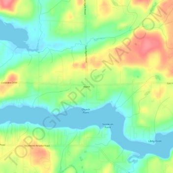
Name: Agate topographic map, elevation, terrain.

Location: Agate, Mason County, Washington, United States (47.19343 -123.03237 47.23343 -122.99237)

Average elevation: 32 m

Minimum elevation: -4 m

Maximum elevation: 81 m

Other topographic maps

Click on a map to view its topography, its elevation and its terrain.

Belfair

United States > Washington > Mason County

Average elevation: 65 m

Price Lake

United States > Washington > Mason County

Average elevation: 326 m

Oakland Bay

United States > Washington > Mason County > Shelton

Average elevation: 36 m

Shelton

United States > Washington > Mason County

Average elevation: 54 m

Lake Cushman

United States > Washington > Mason County

Average elevation: 410 m

Allyn

United States > Washington > Mason County > Allyn

Average elevation: 47 m

Shelton

United States > Washington > Mason County

Average elevation: 54 m