Geolocate

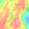
Belfair topographic map

Click on the map to display elevation.

About this map
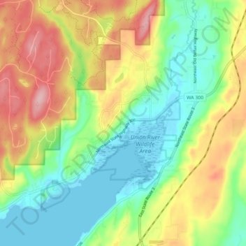
Name: Belfair topographic map, elevation, terrain.

Location: Belfair, Mason County, Washington, United States (47.41664 -122.88748 47.47625 -122.80076)

Average elevation: 65 m

Minimum elevation: -2 m

Maximum elevation: 162 m

Other topographic maps

Click on a map to view its topography, its elevation and its terrain.
Matlock

United States > Washington > Mason County

Average elevation: 133 m

Mount Ellinor

United States > Washington > Mason County

Mount Ellinor is a peak in the Olympic Mountains of Washington, United States. It is located in an area designated as the Mount Skokomish Wilderness. The mountain is a popular day hike in the summer months; the summit is reachable via a steep-but-brief 3.3-mile (5.3 km) trail which gains about 3,200 feet (980…

Average elevation: 1,334 m
Price Lake

United States > Washington > Mason County

Average elevation: 326 m

Lilliwaup

United States > Washington > Mason County

Average elevation: 114 m

Belfair

United States > Washington > Mason County

Average elevation: 63 m

Lilliwaup

United States > Washington > Mason County

Average elevation: 114 m

Agate

United States > Washington > Mason County

Average elevation: 32 m

Hoodsport

United States > Washington > Mason County

Average elevation: 62 m

Ayock

United States > Washington > Mason County

Average elevation: 65 m

Deckerville

United States > Washington > Mason County

Average elevation: 123 m

Gear up for your next adventure:

🥼Base Layers - Thermal base layers for temperature regulation
🛰️Outdoor GPS Navigation - Navigation devices for remote and off-grid areas
🔋Solar Chargers - Eco-friendly charging solutions for outdoor use
👕Merino Base Layers - Natural temperature regulation for cold weather hiking and camping
🥾Women's Waterproof Hiking Boots - High-performance trekking boots designed for all-weather comfort

As an Amazon Associate, this site earns from qualifying purchases at no extra cost to you.