Geolocate

Gaffney topographic map

Click on the map to display elevation.

About this map

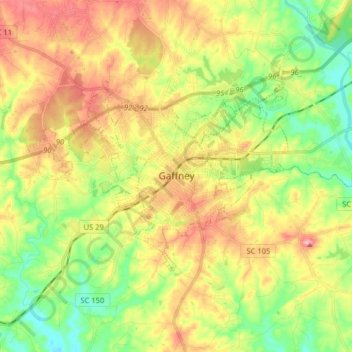
Name: Gaffney topographic map, elevation, terrain.

Location: Gaffney, Cherokee County, South Carolina, 29342, United States (35.03622 -81.71755 35.10685 -81.55761)

Average elevation: 219 m

Minimum elevation: 158 m

Maximum elevation: 292 m

Other topographic maps

Click on a map to view its topography, its elevation and its terrain.

Maud

United States > South Carolina > Cherokee County

Average elevation: 279 m

Gear up for your next adventure:

🎿Telescopic Trekking Poles - Reduces knee strain on steep topographic descents
🧰Survival Kits - Emergency tools for remote environments
🛰️Outdoor GPS Navigation - Navigation devices for remote and off-grid areas
🔦Waterproof LED Headlamps - Hands-free lighting for evening treks and emergency navigation
🧢Waterproof Hiking Hats - Keep the rain off your face while studying topographic maps

As an Amazon Associate, this site earns from qualifying purchases at no extra cost to you.