Geolocate

Armutlu topographic map

Click on the map to display elevation.

About this map

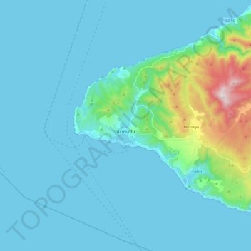
Name: Armutlu topographic map, elevation, terrain.

Location: Armutlu, Yalova, Marmara Region, Turkey (40.45623 28.77964 40.59162 29.01158)

Average elevation: 105 m

Minimum elevation: 0 m

Maximum elevation: 904 m

Other topographic maps

Click on a map to view its topography, its elevation and its terrain.

Delmece Yaylası

Turkey > Yalova > Çınarcık

Average elevation: 774 m

Gear up for your next adventure:

🖼️Topographic Map Art - Decorative 3D-effect posters of famous UK peaks and regions
📢Survival Whistles - Essential safety gear for signaling for help in mountain fog
🧭Emergency Beacons - Safety beacons for remote outdoor locations
👟Heavy Duty Boot Laces - Always carry a spare for your hiking footwear
🎿Telescopic Trekking Poles - Reduces knee strain on steep topographic descents

As an Amazon Associate, this site earns from qualifying purchases at no extra cost to you.