
Towthorpe topographic map
Interactive map
Click on the map to display elevation.
About this map
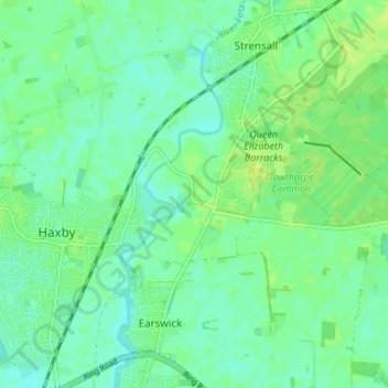
Name: Towthorpe topographic map, elevation, terrain.
Average elevation: 18 m
Minimum elevation: 12 m
Maximum elevation: 25 m
Other topographic maps
Click on a map to view its topography, its elevation and its terrain.
Tower Gardens, St George's Field
United Kingdom > England > York > York
Tower Gardens, St George's Field, Bishophill, York, England, United Kingdom
Average elevation: 15 m
Fulford
United Kingdom > England > York > York
Fulford, York, England, United Kingdom
Average elevation: 12 m
Knapton
United Kingdom > England > York > York
Knapton, Rufforth with Knapton, York, England, YO26 6QH, United Kingdom
Average elevation: 18 m
Crockey Hill
United Kingdom > England > York > York > Crockey Hill
Crockey Hill, Fulford, York, Yorkshire and the Humber, England, YO19 4SN, United Kingdom
Average elevation: 10 m