
LaGrange County topographic map
Interactive map
Click on the map to display elevation.
About this map
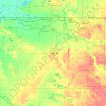
Name: LaGrange County topographic map, elevation, terrain.
Location: LaGrange County, Indiana, États-Unis (41.52506 -85.65982 41.75998 -85.19473)
Average elevation: 279 m
Minimum elevation: 243 m
Maximum elevation: 329 m
Other topographic maps
Click on a map to view its topography, its elevation and its terrain.
Westfield
États-Unis > Indiana > Westfield
Westfield, Hamilton County, Indiana, États-Unis
Average elevation: 269 m
New Palestine
États-Unis > Indiana > New Palestine
New Palestine, Hancock County, Indiana, États-Unis
Average elevation: 253 m
Lawrenceburg
États-Unis > Indiana > Lawrenceburg
Lawrenceburg, Lawrenceburg Township, Comté de Dearborn, Indiana, 47025-1974, États-Unis
Average elevation: 168 m
Kokomo
États-Unis > Indiana > Kokomo > Kokomo
Kokomo, Howard County, Indiana, États-Unis
Average elevation: 254 m