Geolocate

Elmabelen topographic map

Click on the map to display elevation.

About this map

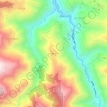
Name: Elmabelen topographic map, elevation, terrain.

Location: Elmabelen, Yağlıdere, Giresun, Black Sea Region, Turkey (40.80280 38.60613 40.84280 38.64613)

Average elevation: 489 m

Minimum elevation: 127 m

Maximum elevation: 940 m

Gear up for your next adventure:

🧴Tick Removal Tools - Small, essential health tool for UK woodland and moorland
🗺️Ordnance Survey Maps - Essential paper maps for hiking across the UK national parks
🧭Professional Hiking Compasses - High-precision liquid-filled compasses for map reading and orientation
📕Outdoor Navigation Books - Learn traditional and modern navigation techniques
💧Hydration Reservoirs - Convenient water bladders for hands-free drinking on the move

As an Amazon Associate, this site earns from qualifying purchases at no extra cost to you.