
Make a donation
Gear up for your next adventure:
As an Amazon Associate, this site earns from qualifying purchases at no extra cost to you.
Mount Horeb topographic map
Click on the map to display elevation.
Make a donation
Gear up for your next adventure:
As an Amazon Associate, this site earns from qualifying purchases at no extra cost to you.
Mount Horeb
Located in southwestern Wisconsin, Mount Horeb is situated in a region referred to as the Driftless Area. While including parts of southeastern Minnesota, northeastern Iowa, and northwestern Illinois, the Driftless Area is a distinct feature of the Wisconsin landscape, stretching across eighteen different counties. In her analysis of place name in the Driftless Area, folklorist Janet Gilmore observes that, "travelers who cross in and out of the territory today will note how its distinctive contours and impressive views emerge from wider, flatter expanses to the east, south, west, and north." These "contours" are the result of glaciers going around this space, smoothing out the surrounding prairie while leaving behind rolling hills. The Village of Mount Horeb is located in southwestern Dane County. The geographic boundary of the Driftless Area runs down the center of the county, creating an east/west topographical division. Mount Horeb is also located near Blue Mound State Park, which also has access to the Military Ridge State Trail. Mount Horeb is located approximately twenty miles southwest of the state capital, Madison, which is also home to the University of Wisconsin–Madison.
Make a donation
Gear up for your next adventure:
As an Amazon Associate, this site earns from qualifying purchases at no extra cost to you.
About this map
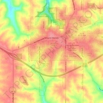
Name: Mount Horeb topographic map, elevation, terrain.
Location: Mount Horeb, Dane County, Wisconsin, United States (42.98472 -89.75294 43.02122 -89.69466)
Average elevation: 357 m
Minimum elevation: 296 m
Maximum elevation: 385 m
Make a donation
Gear up for your next adventure:
As an Amazon Associate, this site earns from qualifying purchases at no extra cost to you.
Other topographic maps
Click on a map to view its topography, its elevation and its terrain.
Make a donation
Gear up for your next adventure:
As an Amazon Associate, this site earns from qualifying purchases at no extra cost to you.
Isthmus Path Prairie Garden
United States > Wisconsin > Dane County > Madison
Average elevation: 262 m
Make a donation
Gear up for your next adventure:
As an Amazon Associate, this site earns from qualifying purchases at no extra cost to you.
Walking Iron County Park
United States > Wisconsin > Dane County > Town of Mazomanie
Average elevation: 236 m
Make a donation
Gear up for your next adventure:
As an Amazon Associate, this site earns from qualifying purchases at no extra cost to you.
Deansville Wildlife Area
United States > Wisconsin > Dane County > Town of York
Average elevation: 264 m