Geolocate

Meppel topographic map

Click on the map to display elevation.

About this map

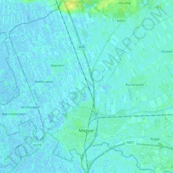
Name: Meppel topographic map, elevation, terrain.

Location: Meppel, Drenthe, Netherlands (52.66799 6.12006 52.77305 6.28670)

Average elevation: 2 m

Minimum elevation: -4 m

Maximum elevation: 16 m

Other topographic maps

Click on a map to view its topography, its elevation and its terrain.

Hondsrug

Netherlands > Drenthe > Exloo

Average elevation: 19 m

Zuidbarge

Netherlands > Drenthe > Emmen

Average elevation: 20 m

Lhee

Netherlands > Drenthe

Average elevation: 11 m

Gear up for your next adventure:

🎒Hiking Child Carriers - Explore the outdoors with the whole family safely
🔪Outdoor Multi-Tools - Versatile tools for gear repairs and food prep in the wild
🍲Portable Camping Stoves - Fast-boiling stoves for hot meals on remote topographic survey trips
🧤Waterproof Overmitts - Extreme weather protection for hikers and mountaineers
👟Men's Trail Running Shoes - Lightweight grip for fast movement over topographic contours

As an Amazon Associate, this site earns from qualifying purchases at no extra cost to you.