Geolocate

Kleinostheim topographic map

Click on the map to display elevation.

About this map

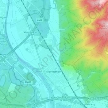
Name: Kleinostheim topographic map, elevation, terrain.

Location: Kleinostheim, Landkreis Aschaffenburg, Bavaria, 63801, Germany (49.98665 9.02973 50.03750 9.10257)

Average elevation: 148 m

Minimum elevation: 96 m

Maximum elevation: 347 m

Other topographic maps

Click on a map to view its topography, its elevation and its terrain.

Pflaumheim

Germany > Bavaria > Landkreis Aschaffenburg

Average elevation: 162 m

Großostheim

Germany > Bavaria > Landkreis Aschaffenburg

Average elevation: 148 m

Heimbach

Germany > Bavaria > Landkreis Aschaffenburg

Average elevation: 259 m

Wasserlos

Germany > Bavaria > Landkreis Aschaffenburg

Average elevation: 185 m

Gear up for your next adventure:

🧢Thermal Beanie Hats - Prevent heat loss from the head in windy summit conditions
🚲Bikepacking Frame Bags - Storage for tools and navigation gear on long off-road rides
👖Packable Overtrousers - Quick-deploy rain protection for legs in sudden storms
🪓Outdoor Multitools - Versatile tools for hiking and camping
🛌Sleeping Mats - Insulated mats for comfortable outdoor sleeping

As an Amazon Associate, this site earns from qualifying purchases at no extra cost to you.