Geolocate

Großostheim topographic map

Click on the map to display elevation.

About this map

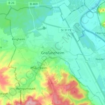
Name: Großostheim topographic map, elevation, terrain.

Location: Großostheim, Landkreis Aschaffenburg, Bavaria, 63762, Germany (49.88075 9.03559 49.96075 9.11559)

Average elevation: 148 m

Minimum elevation: 108 m

Maximum elevation: 270 m

Other topographic maps

Click on a map to view its topography, its elevation and its terrain.

Kahl am Main

Germany > Bavaria > Landkreis Aschaffenburg

Average elevation: 115 m

Kleinostheim

Germany > Bavaria > Landkreis Aschaffenburg

Average elevation: 148 m

Alzenau

Germany > Bavaria > Landkreis Aschaffenburg

Average elevation: 198 m

Wiesen

Germany > Bavaria > Landkreis Aschaffenburg

Average elevation: 454 m

Mainaschaff

Germany > Bavaria > Landkreis Aschaffenburg

Average elevation: 155 m

Gear up for your next adventure:

👟Men's Trail Running Shoes - Lightweight grip for fast movement over topographic contours
🔋Lithium AA Batteries - Long-lasting power that performs well in cold mountain weather
🥾Men's Waterproof Hiking Boots - Durable footwear with deep lugs for muddy and rocky UK terrains
📢Survival Whistles - Essential safety gear for signaling for help in mountain fog
📱Phone Mounts for Hiking - Secure mounts to carry your phone on trails

As an Amazon Associate, this site earns from qualifying purchases at no extra cost to you.