Geolocate

Mainaschaff topographic map

Click on the map to display elevation.

About this map

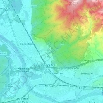
Name: Mainaschaff topographic map, elevation, terrain.

Location: Mainaschaff, Landkreis Aschaffenburg, Bavaria, 63814, Germany (49.97312 9.06484 50.02655 9.11246)

Average elevation: 155 m

Minimum elevation: 101 m

Maximum elevation: 349 m

Other topographic maps

Click on a map to view its topography, its elevation and its terrain.

Pflaumheim

Germany > Bavaria > Landkreis Aschaffenburg

Average elevation: 162 m

Heimbach

Germany > Bavaria > Landkreis Aschaffenburg

Average elevation: 259 m

Wasserlos

Germany > Bavaria > Landkreis Aschaffenburg

Average elevation: 185 m

Großostheim

Germany > Bavaria > Landkreis Aschaffenburg

Average elevation: 148 m

Gear up for your next adventure:

🧥Breathable Waterproof Jackets - Essential rain protection for the unpredictable British climate
🧤Waterproof Overmitts - Extreme weather protection for hikers and mountaineers
🔋Solar Chargers - Eco-friendly charging solutions for outdoor use
🚲Bikepacking Frame Bags - Storage for tools and navigation gear on long off-road rides
🛑Emergency Bivvy Bags - Heat-reflective survival bags for unexpected nights out

As an Amazon Associate, this site earns from qualifying purchases at no extra cost to you.