
Make a donation
Gear up for your next adventure:
As an Amazon Associate, this site earns from qualifying purchases at no extra cost to you.
La Grange topographic map
Click on the map to display elevation.
Make a donation
Gear up for your next adventure:
As an Amazon Associate, this site earns from qualifying purchases at no extra cost to you.
La Grange
La Grange is located at 41°48′29″N 87°52′24″W / 41.80806°N 87.87333°W / 41.80806; -87.87333 (41.807938, −87.873455), about 13 miles (21 km) west of Chicago. The village is roughly flat, only deviating from the elevation of 645 feet by at most ten feet. La Grange is surrounded by incorporated places of similar sizes on all sides except to the South West, where the generously named La Grange Highlands are.
Make a donation
Gear up for your next adventure:
As an Amazon Associate, this site earns from qualifying purchases at no extra cost to you.
About this map
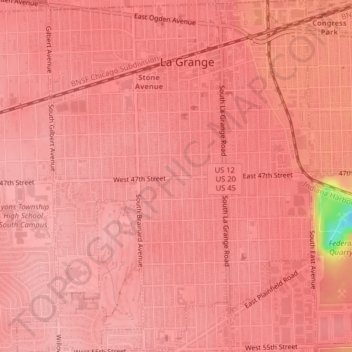
Name: La Grange topographic map, elevation, terrain.
Average elevation: 199 m
Minimum elevation: 99 m
Maximum elevation: 210 m
Make a donation
Gear up for your next adventure:
As an Amazon Associate, this site earns from qualifying purchases at no extra cost to you.
Other topographic maps
Click on a map to view its topography, its elevation and its terrain.
Make a donation
Gear up for your next adventure:
As an Amazon Associate, this site earns from qualifying purchases at no extra cost to you.
Make a donation
Gear up for your next adventure:
As an Amazon Associate, this site earns from qualifying purchases at no extra cost to you.
Make a donation
Gear up for your next adventure:
As an Amazon Associate, this site earns from qualifying purchases at no extra cost to you.
Make a donation
Gear up for your next adventure:
As an Amazon Associate, this site earns from qualifying purchases at no extra cost to you.
Make a donation
Gear up for your next adventure:
As an Amazon Associate, this site earns from qualifying purchases at no extra cost to you.
Chicago, North Shore & Milwaukee
United States > Illinois > Cook County > Northbrook > Williamsburg Square
Average elevation: 198 m
Make a donation
Gear up for your next adventure:
As an Amazon Associate, this site earns from qualifying purchases at no extra cost to you.
Elmwood Park
United States > Illinois > Cook County > Elmwood Park > Elmwood Park
Average elevation: 194 m
Make a donation
Gear up for your next adventure:
As an Amazon Associate, this site earns from qualifying purchases at no extra cost to you.
West Branch Du Page River
United States > Illinois > Cook County > Schaumburg
Average elevation: 249 m