Geolocate

Meadows topographic map

Click on the map to display elevation.

About this map

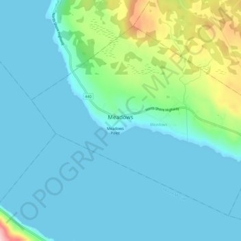
Name: Meadows topographic map, elevation, terrain.

Location: Meadows, Newfoundland, Newfoundland and Labrador, Canada (48.97889 -58.07615 49.00729 -58.02129)

Average elevation: 47 m

Minimum elevation: 0 m

Maximum elevation: 262 m

Other topographic maps

Click on a map to view its topography, its elevation and its terrain.

LaScie

Canada > Newfoundland and Labrador

Average elevation: 98 m

Spot Pond

Canada > Newfoundland and Labrador

Average elevation: 118 m

The Peak

Canada > Newfoundland and Labrador

Average elevation: 67 m

Roundabout

Canada > Newfoundland and Labrador

Average elevation: 65 m

White Horse

Canada > Newfoundland and Labrador

Average elevation: 99 m

Botwood

Canada > Newfoundland and Labrador > Botwood

Average elevation: 17 m

Northern

Canada > Newfoundland and Labrador > Deer Lake

Average elevation: 92 m

The Cabox

Canada > Newfoundland and Labrador

Average elevation: 698 m

Mount Caubvick

Canada > Newfoundland and Labrador

Average elevation: 1,272 m

Gear up for your next adventure:

🧴Tick Removal Tools - Small, essential health tool for UK woodland and moorland
🗺️Ordnance Survey Maps - Essential paper maps for hiking across the UK national parks
🎒Hiking Backpacks - Comfortable backpacks for day hikes and multi-day treks
🧣Neck Gaiters - Protects against wind and sun on exposed ridges and peaks
🧼Biodegradable Soap - Leave-no-trace hygiene for multi-day mountain treks

As an Amazon Associate, this site earns from qualifying purchases at no extra cost to you.